
On July 1, 1867, the passing of the British North American Act signalled the creation of Canada as a nation and unified the Province of Canada (Ontario and Quebec), Nova Scotia and New Brunswick. The population of our newly formed country was more than three million people.
At the time, York Region was known as York County and it was comprised of many communities formed through settlement occurring during the early 1800s. As settlement intensified, more roads and paths were created; the sparsely settled natural forests were slowly cleared for agriculture and many homes and businesses built and established. Many of the buildings and communities in York County existing before Confederation (1867) are still present today.
The richness of York Region's natural environment has attracted human habitation for approximately 11,000 years. For more than 10,000 years, prior to the arrival of Europeans, temporary encampments and semi-permanent villages of various sizes were situated along the river valleys and lake shores of south-central Ontario. The Indigenous peoples living on these lands left no written record of their lives; their legacy includes the oral histories and traditions passed to their descendants and the physical traces of their settlements.
By the late 1600s, European trappers, traders and missionaries began to visit the area and interact with First Nations people. Over the next century, various alliances, conflicts and other associations took place among First Nations, French and English representatives. In the late 1700s, British citizens and American refugees from the American Revolutionary War, as well as more European settlers began to arrive in increasing numbers. This initiated relocations and displacements of First Nations and Métis people.
The Toronto Carrying Place is a centuries-old trail connecting Lake Ontario with the Holland Marsh. Evidence indicates this trail was a vital artery of Southern Ontario for the First Nations inhabiting the area. The trail has two branches, both starting at the Holland Marsh. One ends at Lake Ontario following the Rouge River and the other, ending at Lake Ontario and following the Humber River.
The trail was brought to the attention of Europeans in the 17th century when First Nations hosted French diplomats, and was quickly put to use by Europeans desiring a fast route throughout the region for exploration and fur trading. The Carrying Place was considered a vital trail and its importance to Europeans is supported by its appearance on numerous maps from the 17th and 18th centuries, including an extravagant bronze globe created for Louis XIV in 1690. As most Europeans travelled the western branch, running from the Holland Marsh along the Humber River, it was the western branch that was mapped extensively and listed as the Toronto Carrying Place, Toronto Passage or the Toronto Portage.
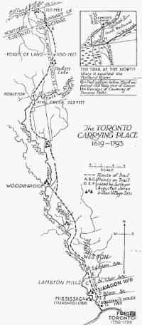
Map, "The Toronto Carrying Place 1615-1793" by C.W. Jefferys, from Toronto during the French Régime: 1615-1793, by Percy J. Robinson, second Edition © University of Toronto Press, 1965. Reprinted with permission of the publisher.
Following the 1787 Toronto Land Purchase, British settlement began in south-central Ontario shortly thereafter. Lieutenant Governor John Graves Simcoe used the Toronto Carrying Place when travelling to Holland Landing in 1793 to survey Upper Canada. It was Simcoe's frustration and confusion with the trail that prompted the construction of a straight British military road in 1794 that became Yonge Street. Despite the construction of a northerly road, many European settlements were established around the Toronto Carrying Place. Settlers often preferred using the trail over settler-created roads in the early 19th century, due to its establishment and better maintenance. The poor maintenance of settler roads became strikingly apparent when the Toronto Carrying Place, rather than Yonge Street, was used for information and transportation during the War of 1812. With increasing British settlement pushing First Nations out of the region, along with a drive to better maintain Yonge Street in the 1820s and 1830s, the Toronto Carrying Place fell out of continuous use. The Carrying Place trail is still largely intact today, weaving across highways and roads, from Toronto's lakeshore through York Region to Holland Landing.
Sources: 1. Boyer, Diane. "Cultural Commotion at the Toronto Carrying Place Trail," in Muséologies. Vol 4: No 2. 2010. Print article 2. Humber Watershed Task Force. "Chapter 2: The History of the Humber," in Legacy: a strategy for a healthy Humber: the report of the Humber Watershed Task Force. Downsview, ON: Metropolitan Toronto and Region Conservation Authority. 1997. Print. 3. Konrad, Victor. "An Iroquois frontier: the north shore of Lake Ontario during the late seventeenth century," in Journal of Historical Geography. Vol 7: No 2. 1981. Print article. 4. Robertson, Heather. Walking into Wilderness: The Toronto Carrying Place and Nine Mile Portage. Winnipeg: Heartland Associates, Inc. 2010. Print. 5. Turner, Glenn. The Toronto Carrying Place: rediscovering Toronto's most ancient trail. Toronto: Dundurn. 2015. Print.
Featured below is a historical Pioneer Map of York County by Jerrine Wells Kinton (c.1940s) highlighting some of the key figures, buildings, events and communities of early settlement.
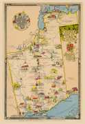
A Pioneer Map of York County by Jerrine Wells Kinton
Learn about York Region's history by exploring the heritage properties telling stories of the families who lived and worked here, the businesses and industries supporting the communities and the prevalent architectural styles of the time.
A selection of heritage, cultural and natural properties, existing prior to 1867, are mapped as close to the original location as possible to the 1860 Tremaine's map of the County of York. Properties that have moved from their original location have an asterisk (*) beside their heritage property name.
Many of the featured properties are designated according to Part IV of the Ontario Heritage Act that helps ensure their conservation for present and future generations. The photographs, descriptions and map provide a glimpse of what York County looked like at the time of Confederation and what York Region looks like today.
Continue to commemorate and celebrate our history by sharing this project with others.
Join the conversation
#YRCanada150 #Canada150.